


The world’s largest iceberg, known for its massive size and long history, is on a collision course with South Georgia Island, a British Overseas Territory in the South Atlantic Ocean. This event is being closely monitored by environmentalists and scientists worldwide due to its potential ecological impacts. Here’s a detailed look at the iceberg’s journey, the geography of the region, and the risks involved.
The Journey of the Iceberg
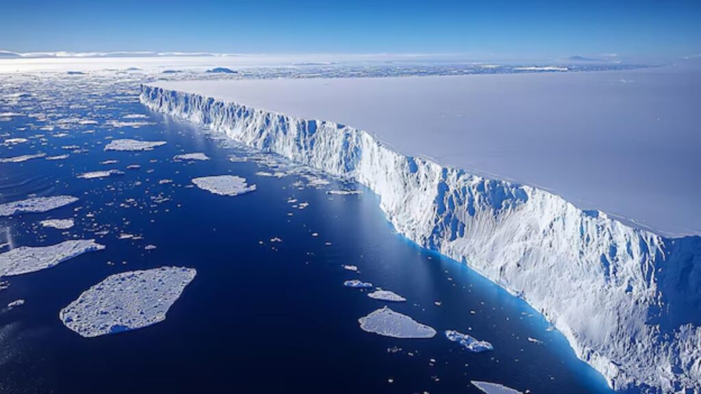
This massive iceberg, estimated to be approximately 4,000 square kilometers in size, originated from Antarctica’s Ronne Ice Shelf in 1986. For nearly 35 years, it remained stuck in the Weddell Sea, a part of the Southern Ocean near Antarctica, due to its immense weight and size. In recent years, it dislodged and began its northward drift, propelled by ocean currents.
The iceberg has now reached the vicinity of South Georgia Island, where its trajectory indicates a likely collision. Scientists have been tracking its movement using satellites, capturing detailed images and videos to study its impact and predict future risks.
Geography of South Georgia Island

Potential Ecological Impacts
The iceberg’s collision with South Georgia could have significant consequences for the island’s ecosystem:
- Endangered Birds and Marine Life: The iceberg could disrupt feeding grounds for seals, penguins, and other wildlife by blocking access to nutrient-rich waters. The underwater portion of the iceberg may also damage seafloor habitats.
- Marine Navigation Risks: South Georgia and the surrounding areas are frequented by icebergs drifting from Antarctica. Ships passing through this region must navigate carefully to avoid accidents, reminiscent of the Titanic disaster.
- Oceanic Currents and Climate: The melting iceberg will release large amounts of freshwater into the ocean, potentially altering local salinity levels and impacting ocean currents. This could have broader implications for global climate systems.
The History Behind the Iceberg
The iceberg’s name and classification follow a standard sequence used by scientists. Icebergs are identified based on the ice shelf they originate from and their order of detachment. This particular iceberg, over the years, has maintained its massive size, making it one of the largest recorded in history.
Challenges in Tracking Icebergs
Tracking icebergs in the Southern Ocean is a complex task. Agencies like NASA and the British Antarctic Survey use satellite imagery to monitor these massive ice chunks. The Southern Ocean, also known as the Antarctic Ocean, is characterized by its turbulent waters and harsh weather conditions, making navigation and research difficult. The area near the Weddell Sea, often referred to as the “Iceberg Alley,” is particularly notorious for iceberg formation and drift.
The Iceberg’s Size: A Perspective
Reports comparing the iceberg’s size to the Indian state of Kerala have been widely circulated but are inaccurate. Kerala covers an area of over 38,000 square kilometers, making it much larger than the iceberg. A more apt comparison is with Delhi, as the iceberg is roughly 2.75 times the size of the Indian capital.
Future Risks and Monitoring
Scientists are keeping a close watch on the iceberg’s progress to assess its potential impact on South Georgia Island. The data collected from this event will provide valuable insights into how such massive ice structures influence ecosystems and global climate patterns. With advancements in satellite technology and oceanographic research, the risks posed by icebergs can be better understood and mitigated.
This unprecedented event serves as a stark reminder of the dynamic and fragile nature of Earth’s polar regions. As the iceberg inches closer to South Georgia, the world waits to see how this massive collision will unfold and what lessons it will offer for understanding our planet’s changing climate and ecosystems.
Also Read: China’s DEEPSEEK R1 Shocks the World: A Game-Changer in AI Development
Follow Fusion IAS